COVID-19: Mobility Strategy

Share COVID-19: Mobility Strategy on Facebook Share COVID-19: Mobility Strategy on Twitter Share COVID-19: Mobility Strategy on Linkedin Email COVID-19: Mobility Strategy link

Welcome! This page is your resource for how the city is responding to essential mobility and transportation needs during the pandemic.


Please take a moment to fill out our user survey. Your input will help us understand how the streets worked, how people used them, and what the future holds for shared streets.

We want to hear from you!

Current Mobility initiatives to help keep residents safe during this time include:

We have learned a lot from this effort to implement citywide quick-build traffic calming over the summer. We're grateful to all of our dedicated residents who've taken the time to let us know what's working and what could be improved. We know that it's a big challenge to change behavior - drivers are used to using the streets without pedestrians in them, and signs and flex posts did not make everyone feel safe enough to use our streets for walking and biking. Reclaiming our streets to make them safer for low-carbon active transportation is a long-term goal, and we are working everyday to figure out the best way to achieve it.

Read more below for information on these projects and check out the Information section with answers to frequently asked questions. If you don't see your question there, please ask us one here, or email us at transportation@somervillema.gov.

For information on other Mobility Division planning and projects, please refer to the main Mobility Division web page.

Current Updates

Update 11/30/20:

Starting on Monday, November 30th, the City will begin to decommission the Shared Streets network for the winter season, including sawhorses and flex post traffic calming. The Mobility Division will be undertaking a formal evaluation of the program, including analysis of traffic data, best practices and lessons learned, and planning next steps for tactical traffic calming for the 2021 season.

Update 9/24/20: Two important updates from the Mobility Division -

  • Some Shared Streets are being decommissioned for the year: Due to the amount of construction traffic in the area of South St., the Shared Streets in this neighborhood were decommissioned (South, Windsor, and Columbia). We’re updating the interactive map, website, and Google maps to reflect these changes.
  • New COVID-response transit initiatives: check out our new website that provides information on the quick-build bus and bike lanes that the City is implementing to further help our residents and the region stay safe and get where they need to go during the pandemic.

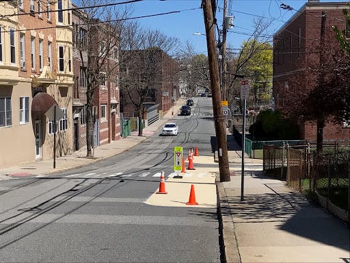
Update 9/14/20: At the end of July, the Mobility Division installed the shared street entry treatments throughout the remaining network (Shared Streets and Shared Curbs interactive map). After that, we worked to plan installation of the final shared street segment for this year - Morrison Ave. Morrison was tricky - due to the high traffic volumes, we didn't think entry treatments could be installed without other traffic calming. Therefore, we used Morrison as the first test location for our adjusted traffic calming approach (photos below). Our new approach includes:

  • better signage (10 mph advisory speed limit signs and yield/slow for pedestrian and bicyclist signs), and
  • more vertical traffic calming (more flex posts installed at intersections to slow turning vehicles and create "neck downs" to narrow the street in certain areas so cars have to slow down and yield to oncoming vehicles.


Update 7/28/20: It's been a busy month in Shared Streets world. We've been monitoring the streets (thank you to our volunteers!), listening to residents, planning improvements to shared streets design, and strategizing the rollout of all of the remaining shared streets.

Here are some of the main things to be aware of -

  • The remaining shared streets will be implemented in two parts - First, we'll install the shared street entry treatments (sawhorse pairs with “Local Access Only” and “Shared Street” signs). If everything goes smoothly, we should have a good chunk of this first part of the work completed this week. Second, we'll take a little more time to plan out appropriate traffic calming approaches on each street with flex posts, paint, and signage. This will be completed over the next few weeks. For an overall view of shared streets citywide, refer to the interactive map. We hope that this approach will allow us to implement all of the shared streets sooner.
  • We're testing new approaches to slow cars on shared streets - You may have noticed that the West Somerville shared streets have white flex posts rather than the green traffic cones. We're adapting our approach as we learn what works and what doesn't. While the flex posts stay in place much better than the cones, we're also experimenting with different layouts of flex posts (to create extra turns in the road to help cars slow down) as well as green paint on the streets to help people recognize that they're on a shared street. Last week, we went out to the East Somerville shared streets and implemented these new approaches (see photo below for what these layouts look like). Let us know what you think!

  • We're listening to our community - We've heard from you - our residents and our community - that the operation of shared streets isn't perfect and changing drivers' behavior takes time. Cars continue to drive too fast, and it doesn't feel safe to walk or bike in the streets. We have noticed this too, and we're working to refine our approach to traffic calming on these streets.

Shared streets and the concept of citywide quick-build traffic calming is new to all of us. It is still early in implementation and we realize that drivers will need some time to adjust to shared streets and changes to their travels. Our initial intent with shared streets was to provide more space for people to be outside during the pandemic, make essential trips, and maintain safe physical distance. We've also noticed and heard from residents that speeds have increased during this time of decreased traffic. Now, as traffic is starting to return to pre-COVID levels, many residents are still at home most of the day and even if you're walking on the sidewalk, lower traffic volumes and slower speeds will create safer pedestrian conditions on our streets. Our goal is to test out new, quick-build, and low-cost interventions to create streets with less cut-through traffic, slower car speeds, and safe and welcoming conditions for pedestrians and bicyclists.

Update 6/23/20: Elm Street shared curbs was installed on Monday (6/22) and Phase 2 of shared streets was installed today! Check out the photos, interactive map, and the streets in real life. Let us know what you think. A big shout out to Somerville DPW, Somerville Fire Department and Somerville Police Department for their support prepping and delivering materials, playing a key role in setup, keeping us safe from traffic during setup, and all of their support in these important COVID-19 response efforts!

Update 6/19/20: Check out our volunteer Shared Streets monitoring program. To build-out, keep track of, and evaluate shared streets for essential trip making throughout the city, we need your help! The monitoring program asks volunteers to keep an eye on and collect data about a shared street 2-3 times per week. This helps us understand how the shared streets are working, how people are using them, and how the materials we're using are functioning. If you're interested, please email transportation@somervillema.gov for more information.

Update 6/15/20: We're working on an interactive map of the shared streets and shared curbs that will hopefully make it easier for everyone to zoom in to see more detail about the locations of shared streets and how they connect into your neighborhood. Additionally, we're adding information about the locations of signs and saw horses, so that volunteers who are helping us maintain the shared streets can more easily see how the streets were initially laid out. Let us know what you think!

Update 6/02/20: Phase 1 of Somerville's Shared Streets was installed yesterday! Check it out and let us know what you think! Over the coming days, we will be monitoring the streets, replacing or moving signs as needed, and observing how this new approach is working - input from you is a key part of this! As you'll see, the network is being implemented with sawhorses and cones. These light touch materials will allow us to be flexible and make adjustments as we see how these new shared streets work and when we hear from you.

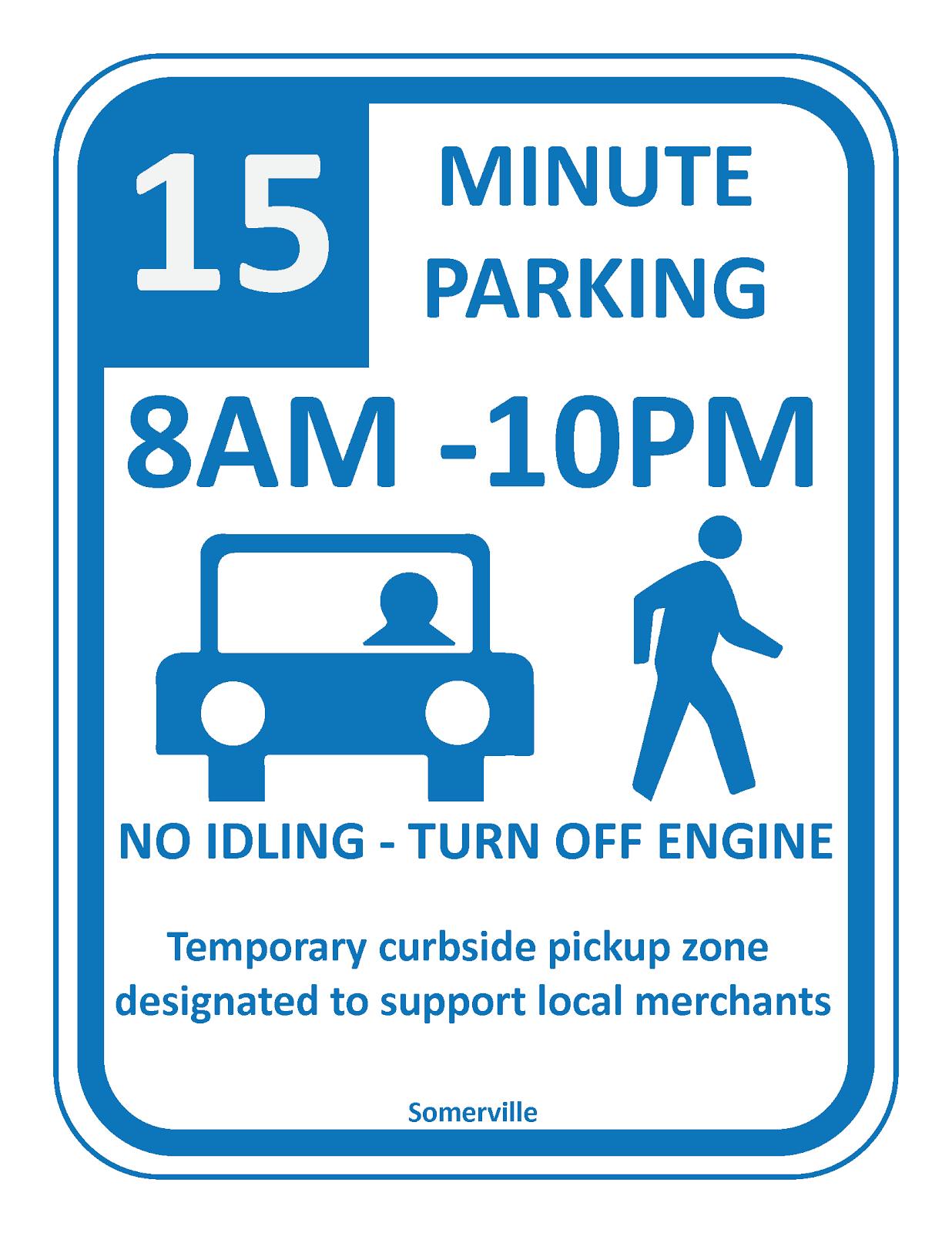
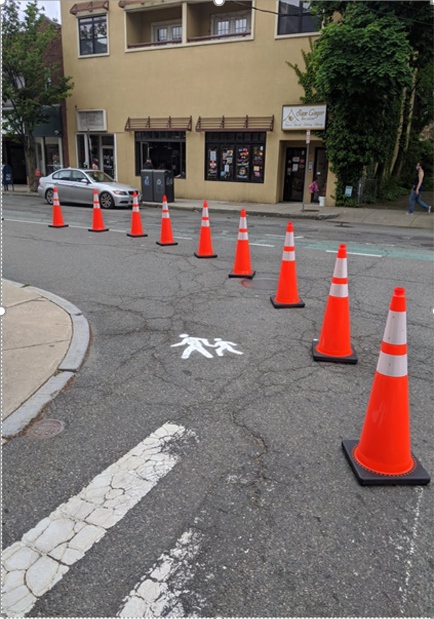
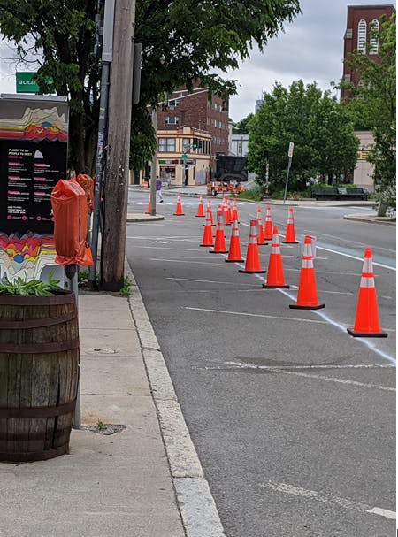
Update 5/29/20: The Shared Curbs pilot in Union Square was installed this morning. Check out the photos and let us know what you think! The pilot implements extended sidewalks with cones, painted pedestrian symbols on the street, and short-term (15 min.) parallel parking spaces for pick-up/drop-off at local businesses. ADA parking spaces are also maintained in front of these businesses.


Stay In Touch

The most up-to-date general information about the virus, how the city is responding, and resources for residents can be found at SomervilleMA.gov/coronavirus. You can also sign up for city alerts to get general, citywide updates as they are announced.

For other ways to get involved in mobility issues in the city, check out the Bicycle Advisory Committee and the Pedestrian and Transit Advisory Committee.

  • Shared Streets

    Share Shared Streets on Facebook Share Shared Streets on Twitter Share Shared Streets on Linkedin Email Shared Streets link
    supporting image

    What are Shared Streets?

    The city is planning temporary changes to city streets to give people more space to get around in their neighborhoods car-free and safely during this time. While it remains safest to stay distanced from others during this time, we know people need to travel from their homes to make essential trips to grocery stores, food pantries, or medical appointments. Additionally, getting fresh air and exercise can be hard to do at home. In the early mornings and evenings when it's cooler outside, you can use shared streets to walk or bike and make trips to essential services.

    These streets will remain open to local vehicle traffic, deliveries, and emergency vehicles, while discouraging drive through vehicle traffic. With slower speeds and fewer cars, these residential streets will be prioritized for bicyclists and pedestrians to navigate and maintain physical distance (at least 6 feet!) while making daily car-free trips to schools, grocery stores, and other essential locations.

    This approach, implementing shared streets with quick-build materials throughout the city, is new to all of us. We're implementing it in phases and with flexible tools (think temporary signs and cones) in order to be sure that we get it right and that we can be responsive to residents' needs and experiences. We're working on an interactive map that we will continue to update throughout this process. As we see how the streets are working, get feedback from residents, and adjust to the changing business operations and commuting patterns during this time, we anticipate making changes to shared streets.

    Use the feedback channels on this page to tell us what you think - what's working well and what could be improved.


    Why is the city doing this now? Why were these streets chosen as part of the network?

    We are implementing Shared Streets now as part of the city's comprehensive response to the pandemic. COVID-19 exacerbates existing inequalities that we see around our city. While some of us are able to limit our potential exposure to the virus by working from home and getting essentials delivered, many people do need to travel outside their homes during this time. Specifically, low income and other underserved communities may not have a choice other than walking, biking, and taking transit to access jobs, groceries, healthcare, and other essential errands. Nearly 1 in 4 households in Somerville do not have access to a car, and 2 in 4 households have access to only one vehicle. Providing a walkable and connected network of streets that people can use to get around the community without a car is a key element to keeping us all safe and healthy.

    The overall vision of Shared Streets is to create multiple north-south and east-west connections across the city to help people walk to essential destinations (the grocery stores in the city,

    the public schools that are functioning as food pantries during this time, and some of the medical buildings in the city or immediately on the border). A recognized challenge that we are attempting to solve is the lack of adequate space for walking on sidewalks during this pandemic time combined with the recognition that residents need to walk to make essential trips.

    Some larger roads around the city do have generally wide enough sidewalks for walking and maintaining appropriate social distance, but many of the smaller, residential streets do not.

    As we were planning out the shared street layout within the city, we used the following framework to guide the selection of the initial streets:

    - There should be connections within each ward that connect to essential locations within that ward (grocery stores, food pantries, medical offices, etc.)

    - Shared streets should be on residential streets

    - When segments of the shared streets do have to cross a major road we suggest connections on the map that help people cross at signalized crossings. If people have to walk along a portion

    of a busier road to reach the next shared street segment, we suggest connections where the majority of the existing sidewalk is a minimum of 8 feet wide.

    We recognize that these connections across or along major roads create gaps in a fully connected shared streets network. As we continue to implement shared streets, monitor their function, and hear what residents want and need, we aim to make continuous improvements and explore opportunities to add shared streets in other areas, expand sidewalks along major roads, and improve/create a safer network for bikes.

    How do shared streets work for people driving?

    Shared Streets will be closed to through traffic - people driving should not use Shared Streets unless necessary to reach a final destination. Shared Streets are open only to local traffic (abutters, their visitors, and deliveries) as well as for emergency services, street cleaning and trash/recycling collection. Shared Streets will be marked with city signage and barricades at key entrances and with temporary traffic calming treatments along the street. All drivers using Shared Streets should drive slowly and safely, and should expect to see people walking and biking along the street.


    How do shared streets work for people walking or biking?

    People can safely distance themselves from neighbors when walking, jogging, and biking along these streets and should always maintain at least 6 feet of space from others and remain aware of their surroundings at all times.

    All Shared Streets allow two-way travel for bicycling, and people biking should expect to ride slowly and carefully, sharing space with pedestrians. People should use their best judgement when using Shared Streets to avoid crowding, and should use other quiet neighborhood streets if Shared Streets appear too busy.


    What about vehicle traffic that needs to use these Shared Streets?

    Shared Streets remain accessible for abutters, deliveries, emergency services, street cleaning, and trash/recycling collection. People driving should not use Shared Streets unless absolutely necessary to reach a final destination. People driving should travel slowly and expect to encounter people walking and biking on the roadway.


    Are Shared Streets safe?

    Shared Streets will utilize city signage, cones, and barricades at key entrances and with temporary traffic calming treatments along the street to reduce vehicle speeds. Regardless of travel mode, all users of shared streets must remain aware of their surroundings at all times and should travel slowly and carefully. Facial coverings are required and group activities are prohibited. People walking should not wear headphones unless they plan to remain on the sidewalk.


    Won’t there be crowding on Shared Streets?

    City Staff will continually monitor Shared Streets to ensure that crowding does not occur. By using temporary and flexible materials like cones and saw horses, Shared Streets can be easily modified or removed if needed.


    What can I do to help?

    You can do a few things to help with our Shared Streets initiative -

    • Amplify the Shared Streets message by downloading, printing, and posting informational signage ("Shared Streets Signs" PDF under Important Documents) along the Shared Streets corridors - on poles, your own parked vehicle, and/or other tools on-hand (neon pedestrian at play figures, traffic cones, etc.).
    • Use #SomervilleSharedStreets to post photos of users’ experiences on Twitter, Instagram, and Facebook.
    • Report any issues, such as signs that have been knocked down on 311 (more information below).
    • Help us maintain the streets. We'll be out daily to monitor how they're working and the placement of cones and signs, and you can help too by putting cones back where they belong if they get moved.


    How can I provide input or report a problem?

    In addition to giving us feedback right on this page (by taking the brief survey, adding to the map, or asking us a question), you can also email us at Transportation@somervillema.gov.

    You can also always give feedback by contacting the City’s 311 Constituent Services Division by calling 3-1-1 (TTY 866-808-4851) or 617-666-3311 from outside the City. You can reach 311 via the 311 mobile app, twitter (@311Somerville), or email (311updates@somervillema.gov).


    Are other cities doing this?

    Yes. The City has been observing and learning from dozens of small and large cities around the world that have closed or limited through traffic on certain streets to provide more space for physical distancing. We are staying in touch with our national peers on strategies and best practices for addressing the mobility impacts of the coronavirus and ensuring that residents can access essential services by all modes of transportation.

  • Shared Curbs

    Share Shared Curbs on Facebook Share Shared Curbs on Twitter Share Shared Curbs on Linkedin Email Shared Curbs link
    supporting image

    What changes are being made to extend sidewalks and who is making them?

    The Shared Streets approach will be applied to lower volume residential streets; however, there is also a need for more pedestrian space on busier arterials and in commercial districts so that pedestrians are able to safely maintain physical distance in these locations.

    The basic approach is to shift all uses over by 5-10 feet - the sidewalks get extended into the parking lane and parking space is transitioned into one of the driving lanes. Similar to our approach with Shared Streets, extended sidewalks will be implemented with cones and other easily moveable materials that allow us to make adjustments very easily, if needed.

    The Mobility Division is planning and implementing this intervention in phases and with close coordination with businesses and with a focus on high-volume or congested locations. In addition, given the extreme density of the city and the multiple demands on our open space and outdoor areas, as we implement extended sidewalks, we are working closely with several other divisions and departments in the city, including Public Space and Urban Forestry, Infrastructure and Asset Management, and Economic Development among others to understand all of the competing uses, the needs of businesses, and potential impacts from construction projects and detours.


    What changes are being made to parking and who is making them?

    We are working to convert some 2-hour metered parking spaces to temporary short-term parking (15 minute) spaces in business districts and in front of businesses. We are doing this by placing bags over parking meters and installing new 15 minute parking signs.

    Similar to the work being done to expand sidewalks in certain high traffic and commercial areas, we recognize that some residents do need to drive to make essential trips. Additionally, as businesses reopen, many of them will continue to operate in more of a pick-up/drop-off capacity. Because of these resident and business needs during the pandemic, the Mobility Division is working with the Parking Department, the Infrastructure and Asset Management Department, business owners, and others to understand, plan, and implement needed changes to parking policies during this time.


    Why are we expanding sidewalks and adding short term parking spaces?

    We have all noticed (and we have heard from many of our constituents!) that many sidewalks in Somerville are not wide enough to maintain necessary physical distancing during this time. We know that people need to be out and making essential trips to grocery stores, pharmacies, food banks, and we all need space to be able to make these trips safely.

    Additionally, as businesses reopen and the weather gets warmer, there is even more need for space - space for people to wait in line to enter stores or for curbside pickup, space for more people to get out to enjoy the warm weather, and continued space for people who do need to drive to have short-term parking spaces for curbside pickup.

    Shifting the uses of the public right-of-way - expanding the pedestrian space while maintaining space in front of businesses for short-term parking needs - allows us to make better use of our limited sidewalk and street area to balance these competing demands while also following public health best practices of maintaining physical distance.


    How do people use Shared Curbs?

    It is critical that we all appreciate that the implementation of an approach like Shared Curbs can significantly change the mobility landscape for some of our residents who rely on wide sidewalks with smooth, uninterrupted surfaces and accessible curb ramps. Part of practicing physical distancing and each doing our part to keep our community healthy is making sure that people who need to use the sidewalks (instead of the expanded pedestrian area in the streets) are able to, and that residents who are more vulnerable or have mobility impairments have the right-of-way when maneuvering sidewalks.

    The city’s intention with expanding sidewalk space is to allow more room for physical distancing (staying at least 6 feet apart) and to creatively accommodate the multiple uses that our sidewalks and streets must meet - walking, rolling, waiting in line, driving, to name a few. Expanded sidewalks are NOT places to gather or play outside of individual households; everyone should continue to maintain at least 6’ of distance from others outside your immediate household.


    If I’m a business owner, how can I request to be considered for a short-term parking space?

    Fill out this survey and someone from the Mobility Division will be in contact with you.


    How can I give feedback or report a problem?

    In addition to giving us feedback right on this page (by taking the brief survey, adding to the map, or asking us a question), you can also email us at Transportation@somervillema.gov.


    You can also always give feedback by contacting the City’s 311 Constituent Services Division by calling 3-1-1 (TTY 866-808-4851) or 617-666-3311 from outside the City. You can reach 311 via the 311 mobile app, twitter (@311Somerville), or email (311updates@somervillema.gov).


    Are other cities doing this?

    Yes. Along with our strategies for Shared Streets and hands-free signals, numerous cities in Massachusetts, around the country, and around the world are implementing temporary solutions to expand sidewalks and provide short-term parking during this time. Here’s one good example from across the river in Bookline.

  • Traffic Calming and Mobility

    Share Traffic Calming and Mobility on Facebook Share Traffic Calming and Mobility on Twitter Share Traffic Calming and Mobility on Linkedin Email Traffic Calming and Mobility link
    supporting image

    What is the city doing to slow vehicle speeds?

    For general information about the city’s traffic calming program, refer to this website and our traffic calming guide.

    There are a few things that guide our maintenance and implementation of traffic calming measures -

    • Every year, we work with the Infrastructure and Asset Management Department to plan the maintenance of existing crosswalks, painted curb bumpouts, and bike lanes.
    • Every year, we also work to plan, design, and implement traffic calming pavement markings and vertical traffic calming interventions (think flexposts) in new locations around the city. Implementation of new traffic calming measures is guided by our Vision Zero action plan which includes analysis of the most dangerous streets and intersections (compiled into a map of the city’s High Crash Network) as well as a map of communities of concern (based on data about the location of Environmental Justice populations). Refer to the plan here.

    The Mobility Division uses the Vision Zero Action Plan to guide our work. There are actions throughout the plan that specifically relate to our commitment to continually implement traffic calming improvements throughout the city, two examples include:

    • Street Design Action 1.2 - Implement tactical intersection safety improvements at five all-way stop or signalized intersections, and
    • Street Design Action 2.4 - Annually install physical infrastructure improvements at four locations on low volume residential streets.

    We also want to hear from you about the areas where you notice drivers going too fast and where you don’t feel safe on foot or on your bicycle. Please use the map on the main page to let us know what you think.

    As a result of reduced vehicle traffic on our streets during this time, cities around the country are experiencing increases in speeding. Our Shared Streets network that is being implemented as part of the city’s COVID-19 response builds on an existing network of low volume residential streets, called neighborways, where bicycles and pedestrians are given priority and vehicle speeds are low. Continued implementation of Shared Streets will help spread awareness throughout the city that vehicles need to slow down and share road space with bicycles and pedestrians.


    Are the street changes being implemented in response to COVID-19 temporary?

    Everything that is being implemented as a direct response to COVID-19 - hands-free signals, shared streets, shared curbs - is being implemented with temporary materials that are easy to move and change based on resident feedback and how the interventions perform once they’re on the ground.

    Slowing vehicle traffic, creating safer streets, and improving the safety and efficiency of sustainable modes of transportation like biking, walking, and taking transit are all city priorities outlined in adopted plans like SomerVision, Somerville Climate Forward, and Vision Zero. Implementing these quick-build and easily changeable responses to COVID-19 will give us all important information about how our streets could function differently in the future.


    Where can I report a traffic problem?

    There are a few ways to provide input to the city on traffic problems that you experience:

    Email us at Transportation@somervillema.gov

    Provide feedback on the map on this website

    Contact the City’s 311 Constituent Services Division by calling 3-1-1 (TTY 866-808-4851) or 617-666-3311 from outside the City. You can reach 311 via the 311 mobile app, twitter (@311Somerville), or email (311updates@somervillema.gov).


    What about residents with mobility impairments?

    Accessibility improvements are considered in every project we undertake. Rehabilitation of sidewalks, improving accessibility to bus stops and rapid transit, and improving accessibility within ¼ mile of schools are all annual actions in the city’s Vision Zero Action Plan that guide the Mobility Division’s priorities and projects.

    Residents with specific mobility concerns or impairments are encouraged to have direct input on the planning and design of city projects through one of our city advisory committees - the Pedestrian and Transit Advisory Committee or the Commission for Persons with Disabilities


    How do you reach non-English speakers?

    The Mobility Division strives to translate key information about our projects into Spanish and Portuguese. If you have questions, thoughts, or concerns, we always welcome feedback through the City’s 311 Constituent Services Division - operators at the Division speak Haitian Creole, Portuguese, and Spanish. If another language is needed, a third-party translation service will join a call.

  • Hands Free Pedestrian Signals

    Share Hands Free Pedestrian Signals on Facebook Share Hands Free Pedestrian Signals on Twitter Share Hands Free Pedestrian Signals on Linkedin Email Hands Free Pedestrian Signals link
    supporting image

    What changes are being made and who is making them?

    There are about 60 signalized intersections that the city has local control over. Before COVID-19, there were some of these signalized intersections where the pedestrian walk signal came on automatically during each signal cycle, and there were some where pedestrians had to push the “beg” button in order to get the walk signal. City staff in the Mobility Division have been working their way around the city making two types of changes:

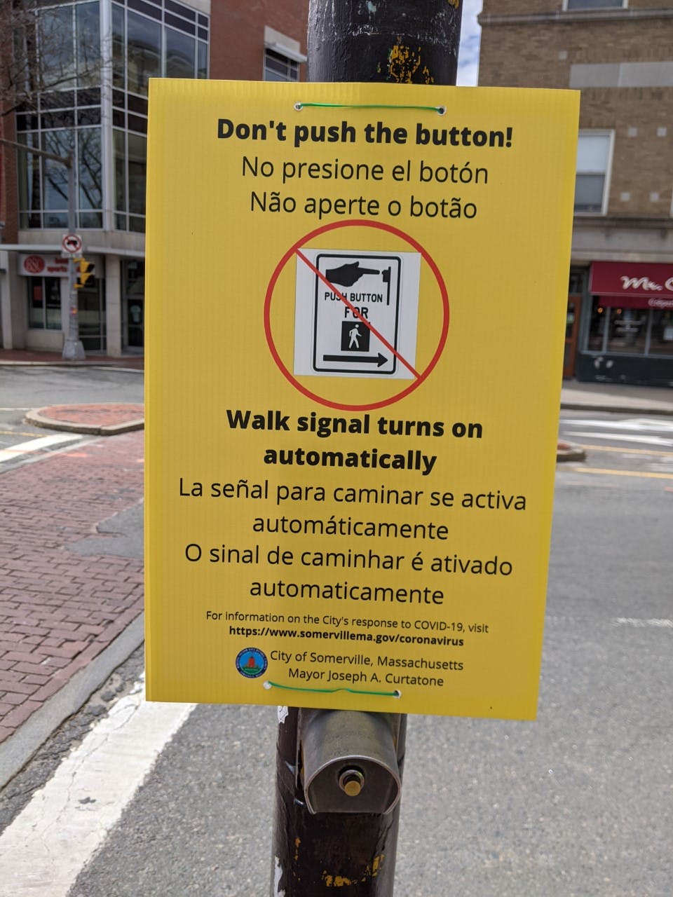
    Hanging signs at locations where the walk signal comes on automatically, so pedestrians know they don’t have to push the button; and,

    Converting signals where the walk sign had to be activated by pushing the button to automatic, and hanging signs to let pedestrians know this change has been made.


    Why are we doing this?

    Over the past several weeks and months, we’ve all learned a lot about COVID-19 - how it’s spread and how to stay safe. One major safety precaution is to eliminate the need to touch surfaces that could have the virus on them, and then unknowingly infect yourself by touching your mouth, nose, or eyes. Pedestrian “beg” buttons at signalized intersections are one of these surfaces, so eliminating the need to touch them, can help keep us all healthy and stop the spread of the virus.


    Are other cities doing this?

    Yes. Making these changes to signals has been a relatively “low-hanging fruit” mobility response undertaken around the country and the world to help keep people safe during the pandemic. Many of our neighbors, including Cambridge and Brookline, have made these changes. Some cities, like Los Angeles and Minneapolis, have worked to convert hundreds of signals to include an automatic pedestrian phase. We are staying in touch with our national peers on strategies and best practices for addressing the mobility impacts of the coronavirus and ensuring that residents can access essential services by all modes of transportation.


    What about audible signals?

    A handful of city-owned signals include audible technology and communicate information about the WALK and DON’T WALK intervals in non-visual formats to pedestrians who are blind or have low vision.

    Within the city, signals with audible technology are of varying ages and levels of technology - at some of the intersections where these signals are located, the audible tones and messages come on automatically when the WALK signal comes on; however, at other locations, pedestrians must still push the WALK button in order to activate the audible features of the signal.

    We understand that this is not ideal, and we are continuing to work to make every intersection in the city as safe and accessible for all pedestrians as possible. Updates will be posted to this site as we are able to address these issues.

    The city is working to make ongoing updates to pedestrian signal technology as well as to improve the safety and accessibility for pedestrians who are blind, have low vision, or are otherwise mobility impaired. This work is guided by the city’s goals to implement the Americans with Disabilities Transition Plan.


    What about places where the signal is only for a crosswalk?

    There are about 16 pedestrian crossing locations throughout the city that are not at typical signalized intersections (in other words, where two or more streets meet and vehicular movements need to be controlled or phased by signals). These signalized pedestrian crossing locations have been installed at crosswalks along corridors to improve safety for crossing pedestrians. Since there is no need to stop cars at these locations unless there is a pedestrian present, the city will be pursuing other improvements to enhance the safety of these locations during COVID-19.


    How can I give feedback or report a problem?

    In addition to giving us feedback right on this page (by taking the brief survey, adding to the map, or asking us a question), you can also email us at Transportation@somervillema.gov.

    You can also always give feedback by contacting the City’s 311 Constituent Services Division by calling 3-1-1 (TTY 866-808-4851) or 617-666-3311 from outside the City. You can reach 311 via the 311 mobile app, twitter (@311Somerville), or email (311updates@somervillema.gov).

Page last updated: 30 Nov 2020, 09:42 AM