COVID-19: Mobility Strategy
Welcome! This page is your resource for how the city is responding to essential mobility and transportation needs during the pandemic.
Please take a moment to fill out our user survey. Your input will help us understand how the streets worked, how people used them, and what the future holds for shared streets.
We want to hear from you!
Current Mobility initiatives to help keep residents safe during this time include:
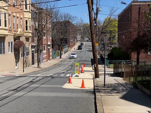
- shared streets (see Shared Streets and Shared Curbs interactive map - we will be continually updating this)
- quick-build bus and bike lanes (check out our new website about all of these projects)
- shared curbs
- traffic calming
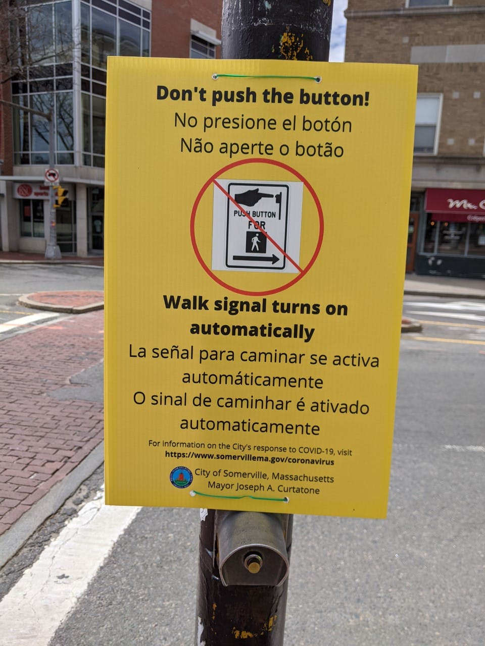
- hands-free pedestrian signals
We have learned a lot from this effort to implement citywide quick-build traffic calming over the summer. We're grateful to all of our dedicated residents who've taken the time to let us know what's working and what could be improved. We know that it's a big challenge to change behavior - drivers are used to using the streets without pedestrians in them, and signs and flex posts did not make everyone feel safe enough to use our streets for walking and biking. Reclaiming our streets to make them safer for low-carbon active transportation is a long-term goal, and we are working everyday to figure out the best way to achieve it.
Read more below for information on these projects and check out the Information section with answers to frequently asked questions. If you don't see your question there, please ask us one here, or email us at transportation@somervillema.gov.
For information on other Mobility Division planning and projects, please refer to the main Mobility Division web page.
Current Updates
Update 11/30/20:
Starting on Monday, November 30th, the City will begin to decommission the Shared Streets network for the winter season, including sawhorses and flex post traffic calming. The Mobility Division will be undertaking a formal evaluation of the program, including analysis of traffic data, best practices and lessons learned, and planning next steps for tactical traffic calming for the 2021 season.
Update 9/24/20: Two important updates from the Mobility Division -
- Some Shared Streets are being decommissioned for the year: Due to the amount of construction traffic in the area of South St., the Shared Streets in this neighborhood were decommissioned (South, Windsor, and Columbia). We’re updating the interactive map, website, and Google maps to reflect these changes.
- New COVID-response transit initiatives: check out our new website that provides information on the quick-build bus and bike lanes that the City is implementing to further help our residents and the region stay safe and get where they need to go during the pandemic.
Update 9/14/20: At the end of July, the Mobility Division installed the shared street entry treatments throughout the remaining network (Shared Streets and Shared Curbs interactive map). After that, we worked to plan installation of the final shared street segment for this year - Morrison Ave. Morrison was tricky - due to the high traffic volumes, we didn't think entry treatments could be installed without other traffic calming. Therefore, we used Morrison as the first test location for our adjusted traffic calming approach (photos below). Our new approach includes:
- better signage (10 mph advisory speed limit signs and yield/slow for pedestrian and bicyclist signs), and
- more vertical traffic calming (more flex posts installed at intersections to slow turning vehicles and create "neck downs" to narrow the street in certain areas so cars have to slow down and yield to oncoming vehicles.


Update 7/28/20: It's been a busy month in Shared Streets world. We've been monitoring the streets (thank you to our volunteers!), listening to residents, planning improvements to shared streets design, and strategizing the rollout of all of the remaining shared streets.
Here are some of the main things to be aware of -
- The remaining shared streets will be implemented in two parts - First, we'll install the shared street entry treatments (sawhorse pairs with “Local Access Only” and “Shared Street” signs). If everything goes smoothly, we should have a good chunk of this first part of the work completed this week. Second, we'll take a little more time to plan out appropriate traffic calming approaches on each street with flex posts, paint, and signage. This will be completed over the next few weeks. For an overall view of shared streets citywide, refer to the interactive map. We hope that this approach will allow us to implement all of the shared streets sooner.
- We're testing new approaches to slow cars on shared streets - You may have noticed that the West Somerville shared streets have white flex posts rather than the green traffic cones. We're adapting our approach as we learn what works and what doesn't. While the flex posts stay in place much better than the cones, we're also experimenting with different layouts of flex posts (to create extra turns in the road to help cars slow down) as well as green paint on the streets to help people recognize that they're on a shared street. Last week, we went out to the East Somerville shared streets and implemented these new approaches (see photo below for what these layouts look like). Let us know what you think!

- We're listening to our community - We've heard from you - our residents and our community - that the operation of shared streets isn't perfect and changing drivers' behavior takes time. Cars continue to drive too fast, and it doesn't feel safe to walk or bike in the streets. We have noticed this too, and we're working to refine our approach to traffic calming on these streets.
Shared streets and the concept of citywide quick-build traffic calming is new to all of us. It is still early in implementation and we realize that drivers will need some time to adjust to shared streets and changes to their travels. Our initial intent with shared streets was to provide more space for people to be outside during the pandemic, make essential trips, and maintain safe physical distance. We've also noticed and heard from residents that speeds have increased during this time of decreased traffic. Now, as traffic is starting to return to pre-COVID levels, many residents are still at home most of the day and even if you're walking on the sidewalk, lower traffic volumes and slower speeds will create safer pedestrian conditions on our streets. Our goal is to test out new, quick-build, and low-cost interventions to create streets with less cut-through traffic, slower car speeds, and safe and welcoming conditions for pedestrians and bicyclists.
Update 6/23/20: Elm Street shared curbs was installed on Monday (6/22) and Phase 2 of shared streets was installed today! Check out the photos, interactive map, and the streets in real life. Let us know what you think. A big shout out to Somerville DPW, Somerville Fire Department and Somerville Police Department for their support prepping and delivering materials, playing a key role in setup, keeping us safe from traffic during setup, and all of their support in these important COVID-19 response efforts!
 |  |
 |  |
Update 6/19/20: Check out our volunteer Shared Streets monitoring program. To build-out, keep track of, and evaluate shared streets for essential trip making throughout the city, we need your help! The monitoring program asks volunteers to keep an eye on and collect data about a shared street 2-3 times per week. This helps us understand how the shared streets are working, how people are using them, and how the materials we're using are functioning. If you're interested, please email transportation@somervillema.gov for more information.
Update 6/15/20: We're working on an interactive map of the shared streets and shared curbs that will hopefully make it easier for everyone to zoom in to see more detail about the locations of shared streets and how they connect into your neighborhood. Additionally, we're adding information about the locations of signs and saw horses, so that volunteers who are helping us maintain the shared streets can more easily see how the streets were initially laid out. Let us know what you think!
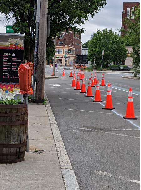
Update 6/02/20: Phase 1 of Somerville's Shared Streets was installed yesterday! Check it out and let us know what you think! Over the coming days, we will be monitoring the streets, replacing or moving signs as needed, and observing how this new approach is working - input from you is a key part of this! As you'll see, the network is being implemented with sawhorses and cones. These light touch materials will allow us to be flexible and make adjustments as we see how these new shared streets work and when we hear from you.

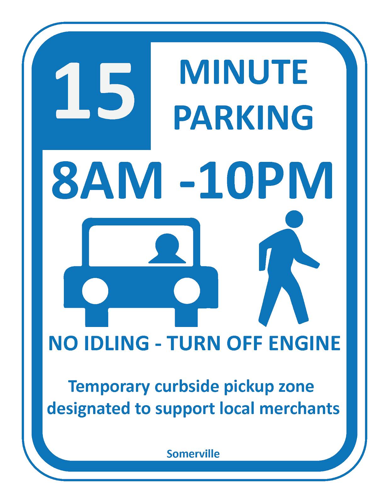
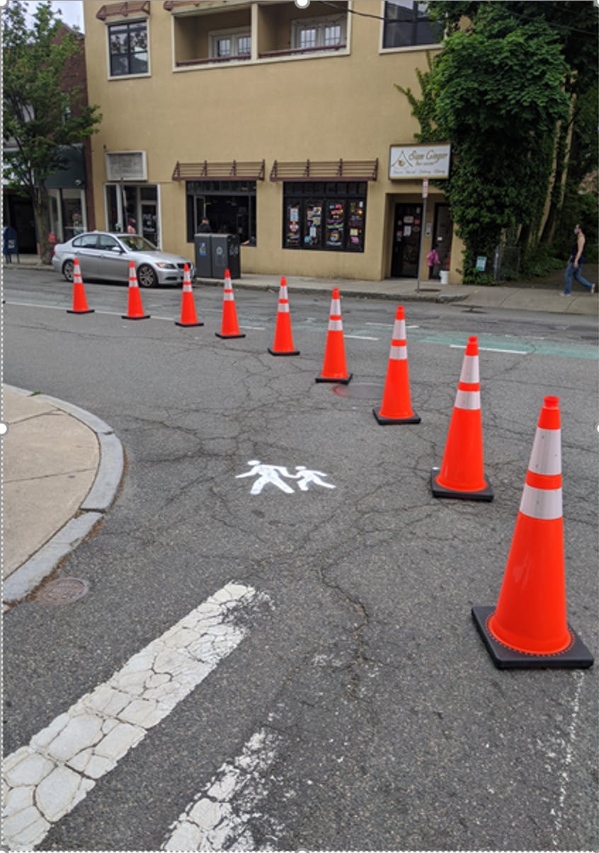
Update 5/29/20: The Shared Curbs pilot in Union Square was installed this morning. Check out the photos and let us know what you think! The pilot implements extended sidewalks with cones, painted pedestrian symbols on the street, and short-term (15 min.) parallel parking spaces for pick-up/drop-off at local businesses. ADA parking spaces are also maintained in front of these businesses.

Stay In Touch
The most up-to-date general information about the virus, how the city is responding, and resources for residents can be found at SomervilleMA.gov/coronavirus. You can also sign up for city alerts to get general, citywide updates as they are announced.
For other ways to get involved in mobility issues in the city, check out the Bicycle Advisory Committee and the Pedestrian and Transit Advisory Committee.
-
Shared Streets
Share Shared Streets on Facebook Share Shared Streets on X (formerly Twitter) Share Shared Streets on Linkedin Email Shared Streets linkWhat are Shared Streets?
The city is planning temporary changes to city streets to give people more space to get around in their neighborhoods car-free and safely during this time. While it remains safest to stay distanced from others during this time, we know people need to travel from their homes to make essential trips to grocery stores, food pantries, or medical appointments. Additionally, getting fresh air and exercise can be hard to do at home. In the early mornings and evenings when it's cooler outside, you can use shared streets to walk or bike and make trips to essentialContinue reading
-
Shared Curbs
Share Shared Curbs on Facebook Share Shared Curbs on X (formerly Twitter) Share Shared Curbs on Linkedin Email Shared Curbs linkWhat changes are being made to extend sidewalks and who is making them?
The Shared Streets approach will be applied to lower volume residential streets; however, there is also a need for more pedestrian space on busier arterials and in commercial districts so that pedestrians are able to safely maintain physical distance in these locations.
The basic approach is to shift all uses over by 5-10 feet - the sidewalks get extended into the parking lane and parking space is transitioned into one of the driving lanes. Similar to our approach with Shared Streets, extended sidewalks will be implemented withContinue reading
-
Traffic Calming and Mobility
Share Traffic Calming and Mobility on Facebook Share Traffic Calming and Mobility on X (formerly Twitter) Share Traffic Calming and Mobility on Linkedin Email Traffic Calming and Mobility linkWhat is the city doing to slow vehicle speeds?
For general information about the city’s traffic calming program, refer to this website and our traffic calming guide.
There are a few things that guide our maintenance and implementation of traffic calming measures -
- Every year, we work with the Infrastructure and Asset Management Department to plan the maintenance of existing crosswalks, painted curb bumpouts, and bike lanes.
- Every year, we also work to plan, design, and implement traffic calming pavement markings and vertical traffic calming interventions (think flexposts) in new locations around the city. Implementation of new traffic calmingContinue reading
-
Hands Free Pedestrian Signals
Share Hands Free Pedestrian Signals on Facebook Share Hands Free Pedestrian Signals on X (formerly Twitter) Share Hands Free Pedestrian Signals on Linkedin Email Hands Free Pedestrian Signals linkWhat changes are being made and who is making them?
There are about 60 signalized intersections that the city has local control over. Before COVID-19, there were some of these signalized intersections where the pedestrian walk signal came on automatically during each signal cycle, and there were some where pedestrians had to push the “beg” button in order to get the walk signal. City staff in the Mobility Division have been working their way around the city making two types of changes:
Hanging signs at locations where the walk signal comes on automatically, so pedestrians know they don’t have toContinue reading


Who's Listening
-
VA
-
-
-